STK Components 二次开发-创建卫星
1.卫星数据
可以用stk 里面自带的 参数帮助文档。
 也可以自己下载
CelesTrak: Current GP Element Sets
这里你所需要的最新卫星数据全有。
其实创建需要的就是卫星的二根数。
给定二根数也可以。
读取数据库中的卫星数据
这个接口优先下载最新的。
var tleList = TwoLineElementSetHelper.GetTles(m_satelliteIdentifier, JulianDate.Now);也可直接指定
var issTle =
    new TwoLineElementSet(@"1 25544U 98067A   10172.34241898  .00007451  00000-0  60420-4 0  3627
                            2 25544  51.6459 209.3399 0009135 352.3227 186.5240 15.71934500664129");
2.创建卫星对象
// Propagate the TLE and use that as the satellite's location point.
var issPoint = new Sgp4Propagator(issTle).CreatePoint();
var m_satellite= new Platform
{
    Name = "ISS",
    LocationPoint = issPoint,
    OrientationAxes = new AxesVehicleVelocityLocalHorizontal(earth.FixedFrame, issPoint),
};
3.设置卫星名称
var labelExtension = new LabelGraphicsExtension(new LabelGraphics
{
    Text = new ConstantCesiumProperty<string>(m_satellite.Name),
    FillColor = new ConstantCesiumProperty<Color>(Color.White),
});
m_satellite.Extensions.Add(labelExtension);
4.设置卫星模型
 // Configure a glTF model for the satellite.
m_satellite.Extensions.Add(new ModelGraphicsExtension(new ModelGraphics
 {
    // Link to a binary glTF file.
    Model = new CesiumResource(GetModelUri("satellite.glb"),CesiumResourceBehavior.LinkTo),
    // By default, Cesium plays all animations in the model simultaneously, which is not desirable.
    RunAnimations = false,
 }));
设置卫星轨迹线颜色
// Configure graphical display of the orbital path of the satellite
m_satellite.Extensions.Add(new PathGraphicsExtension(new PathGraphics
{
    // Configure the visual appearance of the line.
    Material = new PolylineOutlineMaterialGraphics
    {
        Color = new ConstantCesiumProperty<Color>(Color.White),
        OutlineWidth = new ConstantCesiumProperty<double>(1.0),
        OutlineColor = new ConstantCesiumProperty<Color>(Color.Black),
    },
    Width = 2,
    // Lead and Trail time indicate how much of the path to render.
    LeadTime = Duration.FromMinutes(44).TotalSeconds,
    TrailTime = Duration.FromMinutes(44).TotalSeconds,
}));
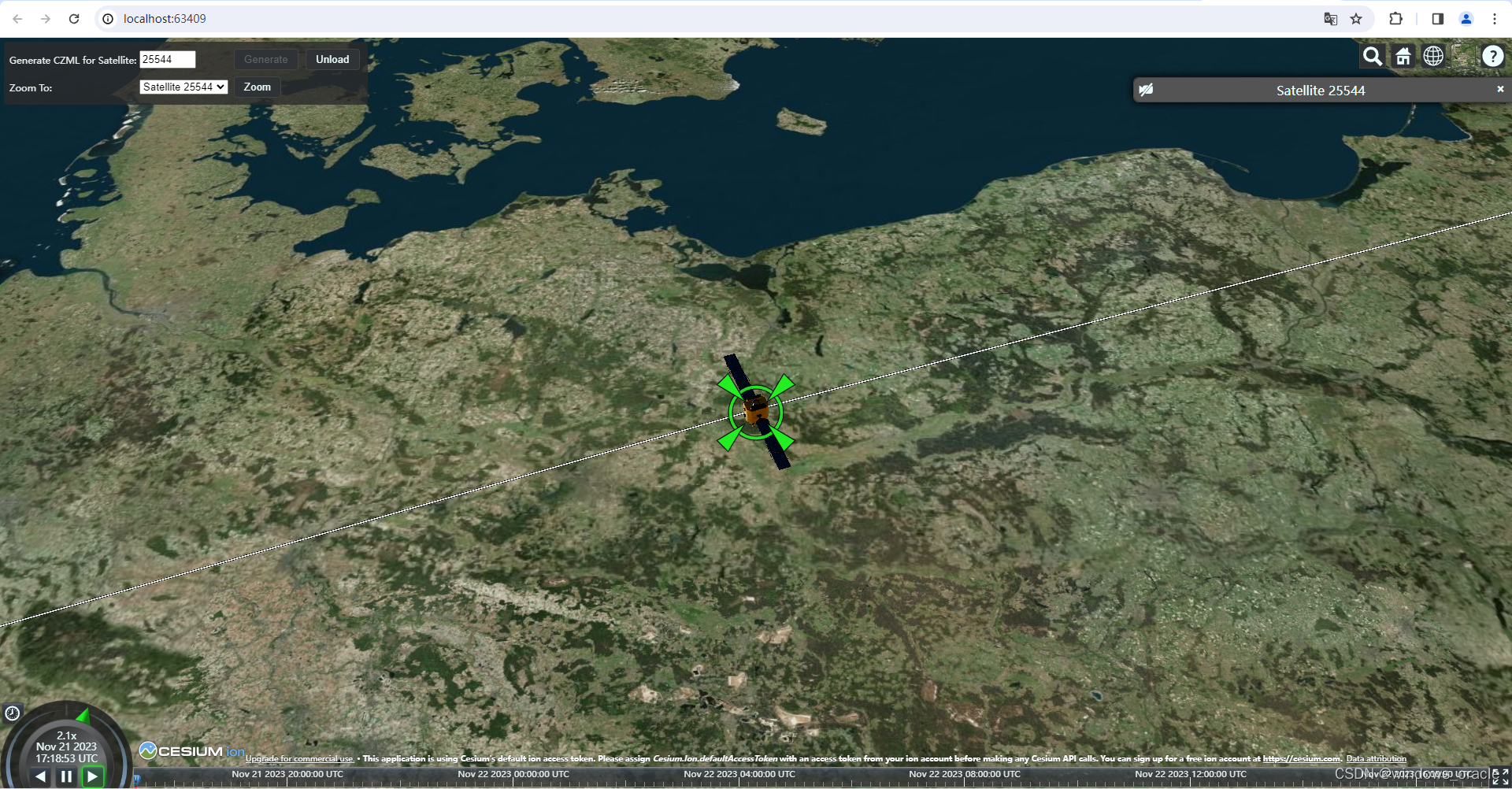
完成后的样子
完整代码
        private void CreateSatellite()
        {
            // Get the current TLE for the given satellite identifier.
            var tleList = TwoLineElementSetHelper.GetTles(m_satelliteIdentifier, JulianDate.Now);

            // Use the epoch of the first TLE, since the TLE may have been loaded from offline data.
            m_epoch = tleList[0].Epoch;

            // Propagate the TLE and use that as the satellite's location point.
            var locationPoint = new Sgp4Propagator(tleList).CreatePoint();
            m_satellite = new Platform
            {
                Name = "Satellite " + m_satelliteIdentifier,
                LocationPoint = locationPoint,
                // Orient the satellite using Vehicle Velocity Local Horizontal (VVLH) axes.
                OrientationAxes = new AxesVehicleVelocityLocalHorizontal(m_earth.FixedFrame, locationPoint),
            };

            // Set the identifier for the satellite in the CZML document.
            m_satellite.Extensions.Add(new IdentifierExtension(m_satelliteIdentifier));

            // Configure a glTF model for the satellite.
            m_satellite.Extensions.Add(new ModelGraphicsExtension(new ModelGraphics
            {
                // Link to a binary glTF file.
                Model = new CesiumResource(GetModelUri("satellite.glb"), CesiumResourceBehavior.LinkTo),
                // By default, Cesium plays all animations in the model simultaneously, which is not desirable.
                RunAnimations = false,
            }));

            // Configure a label for the satellite.
            m_satellite.Extensions.Add(new LabelGraphicsExtension(new LabelGraphics
            {
                // Use the name of the satellite as the text of the label.
                Text = m_satellite.Name,
                // Change the color of the label after 12 hours. This demonstrates specifying that
                // a value varies over time using intervals.
                FillColor = new TimeIntervalCollection<Color>
                {
                    // Green for the first half day...
                    new TimeInterval<Color>(JulianDate.MinValue, m_epoch.AddDays(0.5), Color.Green, true, false),
                    // Red thereafter.
                    new TimeInterval<Color>(m_epoch.AddDays(0.5), JulianDate.MaxValue, Color.Red, false, true),
                },
                // Only show label when camera is far enough from the satellite,
                // to avoid visually clashing with the model.
                DistanceDisplayCondition = new Bounds(1000.0, double.MaxValue),
            }));

            // Configure graphical display of the orbital path of the satellite.
            m_satellite.Extensions.Add(new PathGraphicsExtension(new PathGraphics
            {
                // Configure the visual appearance of the line.
                Material = new PolylineOutlineMaterialGraphics
                {
                    Color = Color.White,
                    OutlineWidth = 1.0,
                    OutlineColor = Color.Black,
                },
                Width = 2.0,
                // Lead and Trail time indicate how much of the path to render.
                LeadTime = Duration.FromMinutes(44.0).TotalSeconds,
                TrailTime = Duration.FromMinutes(44.0).TotalSeconds,
            }));
        }
生成czml
        public void WriteDocument(TextWriter writer)
        {
            // Configure the interval over which to generate data.
            // In this case, compute 1 day of data.
            var dataInterval = new TimeInterval(m_epoch, m_epoch.AddDays(1));

            // Create and configure the CZML document.
            var czmlDocument = new CzmlDocument
            {
                Name = "CesiumDemo",
                Description = "Demonstrates CZML generation using STK Components",
                RequestedInterval = dataInterval,
                // For this demonstration, include whitespace in the CZML
                // to enable easy inspection of the contents. In a real application,
                // this would usually be false to reduce file size.
                PrettyFormatting = true,
                // Configure the clock on the client to reflect the time for which the data is computed.
                Clock = new Clock
                {
                    Interval = dataInterval,
                    CurrentTime = dataInterval.Start,
                    Multiplier = 15.0,
                },
            };

            // Add all of our objects with graphical extensions.
            czmlDocument.ObjectsToWrite.Add(m_satellite);


            // Write the CZML.
            czmlDocument.WriteDocument(writer);
        }